

Returning Customer
I am a returning customer
Register Account
If you already have an account with us, please login at the login form.
Your Account Has Been Created!
Congratulations! Your new account has been successfully created!
You can now take advantage of member privileges to enhance your online shopping experience with us.
If you have ANY questions about the operation of this online shop, please e-mail the store owner.
A confirmation has been sent to the provided e-mail address. If you have not received it within the hour, please contact us.
Account Logout
You have been logged off your account. It is now safe to leave the computer.
Your shopping cart has been saved, the items inside it will be restored whenever you log back into your account.
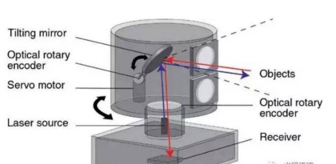
1,The working principle of laser radar
Radar system, is an active sensor, the data formed is a point cloud form. The work of the spectral band in the infrared to ultraviolet, the main transmitter, receiver, measurement control and power components. The working principle is as follows: Firstly, a laser beam is emitted to the measured target, and then the time when the reflected or scattered signal reaches the transmitter, the signal intensity and the frequency change are measured to determine the distance, the moving speed and the orientation of the measured target. In addition, you can measure the atmospheric particles can not see the dynamic situation. Radar's purpose is to accurately measure the target's position (distance and angle), shape (size) and state (speed, attitude), so as to achieve the purpose of detecting, identifying and tracking the target.
2,the status and application of laser radar
Laser technology from its advent until now, although not long, but because it has: high brightness, high directivity, high monochromaticity and high coherence and several other valuable features, and thus in the national defense military, engineering Agricultural production, medical and health and scientific research have a wide range of applications. Radar technology In the western countries are relatively mature development, has been put into commercial operation of the laser radar system (mainly refers to the airborne) are Optech (Canada), TopSys (France) and Leica (USA) and other companies products.
1)Military applications
At present, great achievements have been made in such fields as mine detection laser radar, chemical reagent detection laser radar, atmospheric monitoring laser radar, and biochemical land-based laser radar. In addition, China's attack laser radar has been quite advanced, including the world's most advanced five core technologies: the breakthrough of laser material research, the physical mechanism of laser radiation materials and imaging research breakthrough, a one-time rapid tracking positioning control technology breakthrough, High-density energy reversible conversion of carrier materials breakthrough, a breakthrough laser imaging technology.
2)Wind measurement applications
Doppler wind radar with high resolution, high precision, large detection range, can provide clear wind conditions under the conditions of three-dimensional wind information capabilities. The Doppler wind radar uses the Doppler effect of light to measure the Doppler shift of the laser beam transmitted in the atmosphere and its echo signal to retrieve the space wind velocity distribution. There are mainly coherent (heterodyne) detection and non-coherent (direct) detection of two ways.
3)Meteorological applications
China has set up 12 long-term observation stations for dust storms, forming a nationwide sandstorm monitoring network for the first time. Through advanced observations, simulations and satellite remote sensing joint research to identify the exact source of dust storms in China, the scientific identification of natural factors such as meteorological and climatic conditions and desertification land increased human factors such as sandstorms, accurate warning , Forecast dust storms, to develop a comprehensive and efficient prevention and treatment plan to provide a scientific basis.
4)Medical applications
The Oak Ridge National Laboratory, part of the U.S. Department of Energy, has developed a system that integrates laser and radar systems that reduce the pain of burns. Researchers hope this co-frequency CW laser radar mapping system will remove necrotic skin and muscle from the patient's body. This new system enables 3D laser Radar localization of burned patients' surface tissues to determine the degree of damage. Using probe positioning results, the laser can automatically remove necrotic tissue to facilitate new tissue growth.
5)Application of soil and water conservation monitoring
At present, due to the influence of construction and development in the whole country, great difficulty has been brought to the governance of soil and water loss. According to the survey, the area of soil erosion reaches 1.00 × 10⁴ square kilometers per year due to development and construction throughout the country. radar is more accurate and reliable than the traditional method in terms of measurement accuracy. It can reflect the shape of the field in detail and easily realize the three-dimensional modeling so that the non-contact measurement can be greatly reduced The workload of the field is reduced, and the risk of the field is reduced; meanwhile, many forms of water and soil loss such as excavation slope, collapsing hill and landslide can be measured, and the traditional water and soil conservation can be embarked on the road of "intensive farming”
Conclusion
As the laser radar is a cost, good effect, the use of a wide range of remote sensing means, I believe the future will be more widely used.
If you are interested in laser product,please take a check for the link below:
http://www.raymondcoding.com/laser-marking-machine